
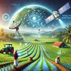
Agriculture has long been the backbone of Kerala’s economy, with lush landscapes yielding everything from rice and spices to tropical fruits and cash crops. However, the state’s farmers have faced mounting challenges over the years — unpredictable weather patterns, fragmented landholdings, soil degradation, and water scarcity, among others. To combat these challenges and ensure sustainable agricultural practices, Kerala has embraced an unexpected ally: space technology.
This article delves into how space technology, particularly satellite-based systems and remote sensing, is transforming Kerala’s agricultural sector — making it more resilient, productive, and sustainable.
1. Precision Farming with Remote Sensing and GIS
One of the most significant contributions of space technology to Kerala’s agriculture is the rise of precision farming. Through remote sensing and Geographic Information System (GIS) technologies, farmers and agricultural planners can monitor crop health, soil conditions, and moisture levels more accurately than ever before.
- Crop Monitoring: Satellite imagery helps track vegetation growth and detect early signs of pest infestations or nutrient deficiencies. For example, Normalized Difference Vegetation Index (NDVI) data, derived from satellite images, indicates plant health by measuring the greenness of crops.
- Soil and Water Management: GIS mapping helps farmers understand soil composition and moisture distribution across fields. This data allows them to optimize fertilizer use and irrigation schedules, reducing costs and environmental impact.
- Yield Prediction: By analyzing weather patterns and crop growth cycles from satellite data, agricultural experts can predict harvest yields. This helps policymakers and farmers plan better for storage, transportation, and market distribution.
2. Weather Forecasting and Disaster Management
Kerala’s farmers are particularly vulnerable to monsoon irregularities, cyclones, and floods — all of which have intensified due to climate change. Space technology plays a critical role in providing accurate, timely weather forecasts and disaster warnings.
- Early Warning Systems: Satellites provide real-time data on cloud formation, wind patterns, and sea surface temperatures, enabling authorities to predict extreme weather events like heavy rainfall or droughts. This helps farmers take preventive measures, such as securing crops or adjusting planting schedules.
- Flood Mapping: During Kerala’s devastating floods in 2018, satellite data was crucial in mapping inundated areas and guiding relief efforts. The same technology is now being used to assess flood-prone regions and develop more resilient cropping patterns.
- Pest and Disease Prediction: Weather data, combined with satellite observations of vegetation changes, helps forecast pest outbreaks — such as the spread of rice blast disease or coconut palm infestations — allowing farmers to respond promptly.
3. Land Use and Crop Diversification
Space-based monitoring helps Kerala’s agricultural planners track how land is being used and identify areas suitable for alternative crops. This is particularly important for a state that relies heavily on cash crops like rubber, coconut, and spices.
- Crop Mapping: Satellite imagery identifies which crops are growing in different regions, helping planners ensure balanced production. It also supports crop rotation strategies to prevent soil depletion and reduce pest cycles.
- Promoting High-Value Crops: By analyzing soil and climate data, experts can recommend alternative, high-value crops that are better suited to certain regions. For example, shifting from water-intensive crops to drought-resistant varieties or medicinal plants is becoming increasingly common.
4. Water Resource Management
Water scarcity is a growing concern for Kerala’s farmers, especially during dry spells. Space technology supports better management of water resources in multiple ways:
- Monitoring Groundwater: Satellites equipped with microwave sensors measure groundwater levels by detecting soil moisture changes. This data helps authorities monitor aquifers and manage water extraction sustainably.
- Irrigation Planning: GIS data aids in designing efficient irrigation systems, ensuring water is delivered precisely where and when it’s needed. For example, drip irrigation systems are optimized using satellite data to target specific crop zones.
- Reservoir Management: Satellite images track water levels in reservoirs and river basins, helping authorities regulate water releases for irrigation while balancing drinking water supply and hydroelectric needs.
5. Supporting Agricultural Research and Policy
Kerala’s agricultural universities and research institutions increasingly rely on satellite data to study long-term environmental changes and develop resilient farming methods.
- Climate Impact Studies: Satellites track rising temperatures, shifting rainfall patterns, and soil erosion rates. This data feeds into research projects aimed at developing climate-resilient crop varieties.
- Carbon Sequestration Monitoring: Kerala’s forests and plantations play a role in carbon absorption. Satellite data helps assess how much carbon is being sequestered — a valuable tool in understanding the role of agriculture in climate change mitigation.
- Policy Planning: The state government uses space technology insights to formulate data-driven policies, such as crop insurance schemes based on satellite-detected yield losses or drought relief programs tailored to affected regions.
6. Bridging the Knowledge Gap: Farmer Empowerment
While technology holds immense potential, it’s only effective if farmers can access and apply the insights. Kerala is making strides in bridging this gap by integrating space technology with grassroots education initiatives.
- Mobile Apps and Information Portals: Platforms like the ‘Kisan Kerala’ app provide farmers with satellite-based weather updates, pest alerts, and soil recommendations — all in regional languages.
- Field Demonstrations: Agricultural extension workers demonstrate how farmers can use GPS-guided equipment and remote-sensing data to optimize planting, irrigation, and harvesting.
- Farmer Cooperatives: Kerala’s robust network of farmer cooperatives plays a key role in ensuring smallholders benefit from satellite technology. Collective bargaining for precision equipment and shared access to data platforms helps make technology affordable.
Conclusion: A High-Tech Green Revolution
Kerala’s integration of space technology into agriculture marks a significant step towards sustainable and resilient farming. From precision agriculture and climate adaptation to water management and crop diversification, satellite-based innovations are empowering farmers to make smarter decisions, improve yields, and protect the environment.
While challenges remain — such as ensuring affordable access to technology for small farmers and improving data interpretation at the grassroots level — Kerala’s progress so far paints a hopeful picture. With ongoing investments in research, infrastructure, and farmer education, space technology promises to lead Kerala into a new era of agricultural prosperity, ensuring that the ‘God’s Own Country’ continues to thrive in harmony with nature and technology.